Barrier Highway State Highway No. 8 |

The flat, straight, featureless Barrier Highway looking east from the Cobb Highway junction near Wilcannia. Jan 2005.
Length: 622km
Eastern Terminus: Mitchell Hwy, Nyngan
Western Terminus: NSW/SA border, Cockburn
Focal Points: Nyngan, Cobar, Wilcannia, Broken Hill, Adelaide
RTA Internal Classification: State Highway No. 8
Proclaimed a State Highway: 7 August 1928
Named: 1959
The Barrier Highway, State Highway No. 8, is a vital east-west highway through outback New South Wales, forming part of the inland route from Sydney to Adelaide – National Route 32. It commences at a junction with the Mitchell Highway at Nyngan and stretches west for 622km across almost featureless plains to the South Australian border at Cockburn. From there the Barrier Highway continues across the border and through South Australia to near Adelaide, but the South Australian section of the Barrier Highway is discussed elsewhere on this site.
The Barrier Highway has carried the National Route 32 shield since 1961.
Click HERE for an overview of the history and development of the Barrier Highway.
Photos of Barrier Highway: Nyngan to Cockburn |
|
 |
AD sign northbound on Mitchell Highway approaching the junction with Barrier Highway, 2km west of Nyngan. Photo taken: December 2006. |
 |
AD sign southbound on Mitchell Highway approaching the junction with Mitchell Highway, 2km west of Nyngan. Photo taken: December 2006. |
 |
ID sign pointing to the beginning of the Barrier Hwy at the junction with Mitchell Highway, 2km west of Nyngan. Photo taken: September 2004. |
 |
AD sign eastbound on Barrier Highway as you approach the the junction with Mitchell Highway, 2km west of Nyngan. This sign marks the eastern end of the Barrier Highway. Photo taken: December 2006. |
 |
RD sign westbound on Barrier Highway as you leave the junction with Mitchell Highway, 2km west of Nyngan. Photo taken: December 2006. |
 |
Rest area RD sign westbound on Barrier Highway near the junction with Mitchell Highway, 2km west of Nyngan. Photo taken: December 2006. |
 |
Barrier Highway looking west towards the level crossing of the Cobar branch railway line, 5km west of Nyngan. Photo taken: December 2006. |
 |
Barrier Highway looking west at the entrance to the AWB Grain Receival depot, 6km west of Nyngan. Note the solar powered street light. Photo taken: December 2006. |
 |
Typical view of Barrier Highway, looking west 17km west of Nyngan. Photo taken: December 2006. |
 |
Barrier Highway looking west at the tiny locality of Miandetta, 22km west of Nyngan. Photo taken: December 2006. |
 |
Fingerboard sign assembly at the junction of Barrier Highway & Gilgai Rooad, Miandetta. Photo taken: December 2006. |
 |
RD sign eastbound on Barrier Highway as you leave Hermidale, 46km west of Nyngan. Photo taken: December 2006. |
 |
Barrier Highway looking west towards the tiny community of Hermidale, 46km west of Nyngan. Photo taken: December 2006. |
1960s style AD sign on Barrier Highway, westbound at Hermidale, 1972. Note the use of capital letters and the omission of NR32 - it is possible that this sign even pre-dates the signposting of NR32. Source: Main Roads, Vol. 38, No. 2, December 1972, p.37 |
|
 |
AD sign northbound on Main Road No. 228 (Nymagee-Hermidale) approaching Barrier Highway at Hermidale. Photo taken: December 2006. |
 |
RD sign westbound on Barrier Highway after the junction with Main Road No. 228 at Hermidale. Photo taken: December 2006. |
 |
Fingerboard sign assembly at the junction of Barrier Highway & the western access road to Hermidale. Photo taken: December 2006. |
 |
Services signage westbound on Barrier Highway as you leave Hermidale. Photo taken: December 2006. |
 |
Typical view of Barrier Highway, westbound approximately 52km west of Nyngan. Photo taken: December 2006. |
 |
Westbound signage for the emergency telephone, located approximately 1km east of Florida Rest Area, 80km west of Nyngan. Photo taken: December 2006. |
 |
Barrier Highway looking west towards the Florida Rest Area near Canbelego, 81km west of Nyngan. Photo taken: December 2006. |
 |
Barrier Highway looking east at the junction with the eastern access road to the tiny mining village of Canbelego, 84km west of Nyngan. Photo taken: December 2006. |
 |
Old black fingerboard sign at the junction of Barrier Highway & the eastern access road to Canbelego village, 84km west of Nyngan. Photo taken: December 2006. |
 |
RD sign eastbound on Barrier Highway as you leave the tiny village of Canbelego, 88km west of Nyngan. Photo taken: December 2006. |
Typical Barrier Highway scene in 1972, 65km east of Cobar. Source: Main Roads, Vol. 38, No. 2, December 1972, p.37 |
|
 |
AD sign westbound on Barrier Highway approaching the junction with former Main Road No. 419 at Canbelego. Photo taken: December 2006. |
 |
New fingerboard sign, looking west on Barrier Highway at the junction with the former Main Road No. 419 (Gilgunnia - Nymagee - Canbelego) at Canbelego. Main Road No. 419 was decommissioned between Nymagee and Canbelego in 1996. Photo taken: December 2006. |
 |
RD sign heading west on Barrier Highway at Canbelego, 43km east of Cobar. Photo taken: December 2006. |
  |
Fingerboard signs at the junction of Barrier Highway & Booroomugga Road, Canbelego. These signs have since been replaced with new signs in preparation for the roll out of alpha-numeric route marking in NSW. Photos taken: December 2006. |
 |
Barrier Highway looking west, 39km east of Cobar. Source: Department of Main Roads, 1973. |
  |
Old and new rest area signage eastbound on Barrier Highway as you leave Cobar. Top photo: January 2005. Bottom photo: December 2006. |
 |
AD sign westbound on Barrier Highway approaching the eastern junction with Kidman Way at Cobar. Note the omission of SR87 - it should be shown staight ahead and left. Photo taken: January 2005. |
 |
ID sign assembly facing northbound traffic at the eastern junction of Barrier Highway & Kidman Way, Cobar. Again note the omission of SR87 for the left turn. Photo taken: January 2005. |
 |
Beautiful old diagrammatic AD sign, eastbound on Barrier Highway approaching the eastern junction with Kidman Way, Cobar. This sign significantly pre-dates the extension of SR87 from Hillston to Bourke. Photo taken: January 2005. |
 |
Dodgy AD sign westbound on Barrier Highway approaching the western junction with Kidman Way, Cobar. Note the absence of reference to SR87 for the right turn, despite the inclusion of Kidman Way. Photo taken: December 2006. |
 |
Dodgy ID sign assembly at the junction of Barrier Highway (Marshall Street) & Kidman Way (Lewis Street), Cobar. Note the omission of SR87 which should be shown for the left turn towards Hillston. Photo taken: January 2005. |
 |
Barrier Highway (Marshall Street) looking west through Cobar town centre. Photo taken: December 2006. |
 |
Looking east through the town centre of Cobar. Jan 2005. |
 |
Distance sign heading west from Cobar. Note the NR32 shield is on a coverplate, presumably over an "A32" shield. Jan 2005. |
 |
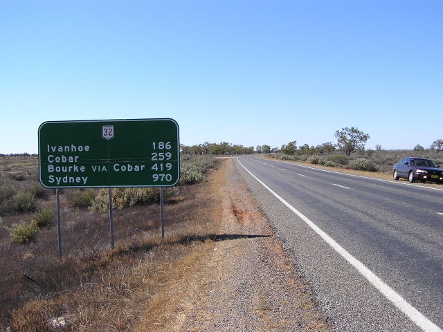
Old black AD sign westbound approaching the turnoff to Ivanhoe, 10km west of Cobar. Jan 2005. |
 |
Another black AD sign at the same intersection, this time northbound on the Ivanhoe-Cobar road. Jan 2005. |
 |
More black signs, this time at Barnato, 83km west of Cobar. Jan 2005. |
 |
Westbound leaving the Emmdale Roadhouse - this sign really shows the isolation of the Barrier Hwy. Jan 2005. |
 |
Distance sign heading south from Wilcannia across the Darling River flood plain. Jan 2005. |
 |
Looking north to the old (left) and new bridges over the Darling River at Wilcannia. Jan 2005. |
 |
AD sign westbound on Barrier Highway approaching the junction with Opal Miners Way, Wilcannia. Note the incorrect gold border - new alpha-numeric route markers in NSW usw a white border. Source: Chris Eastwood, December 2008. |
 |
Unusual sign at the intersection of Barrier Highway & Opal Miners Way, showing the progression of the programme to seal the road to White Cliffs. Note the incorrect National Highway 32 shield. Jan 2005. |
  |
Old and new ID sign assemblies at the junction of Barrier Highway & Opal Miners Way, Wilcannia. Again note the incorrect gold border on the A32 route marker. Top photo: Sam Laybutt, January 2005. Bottom photo: Chris Eastwood, December 2008. |
  |
Old and new RD signs westbound on Barrier Highway as you leave Wilcannia. Note the inclusion of Topar [Roadhouse] on the newer sign. Top photo: Sam Laybutt, January 2005. Bottom photo: Chris Eastwood, December 2008. |
 |
Transition from the Shire of Central Darling into the Unincorporated Area of New South Wales - the only area in the state without a local government organisation. I believe the Roads and Traffic Authority controls all roadworks in the Unincorporated Area. Jan 2005. |
 |
Looking west across the Barrier Range towards Broken Hill. Jan 2005. |
 |
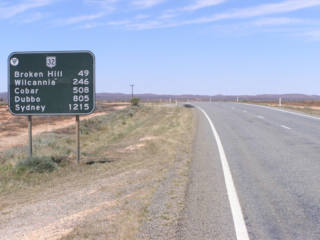
Distance sign heading east from Broken Hill. Note the oddly-designed shield, which is on a coverplate. Jan 2005. |
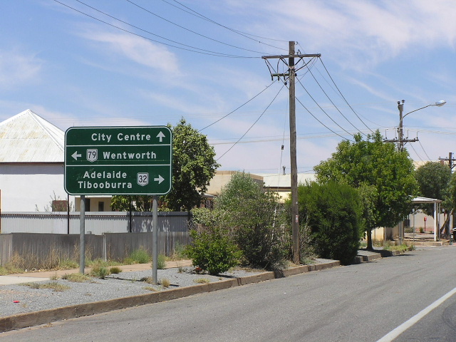 |
Westbound on Argent St approaching Iodide St (Silver City Hwy to the south & Barrier Hwy to the north) in Broken Hill. The signage of National Route 79 ends here, the remainder of the Silver City Hwy in NSW is not signed with a route marker. Jan 2005. |
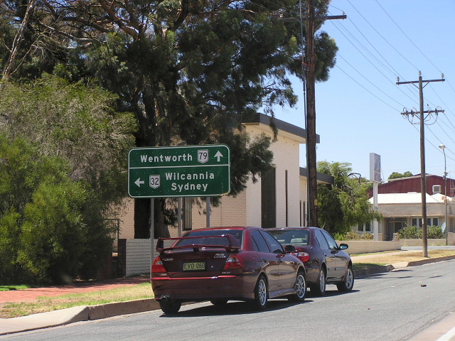 |
Southbound on Iodide St approaching Argent St. Straight ahead is the Silver City Hwy and the beginning of National Route 79. Jan 2005. |
 |
AD sign on Williams St westbound approaching Iodide St in Broken Hill. Jan 2005. |
 |
Looking west along Williams St near Gypsum St. Jan 2005. |
 |
Distance sign heading west from Broken Hill. Unusual that Perth gets a mention! Jan 2005. |
 |
Looking west to the Thackaringa Hills, between Broken Hill and Cockburn. Jan 2005. |
The old route through the Thackaringa Hills in 1958. (DMR) |
|
 |
Distance sign heading east from Cockburn. Jan 2005. |
 |
Looking west into Cockburn. Jan 2005. |
 |
Deteriorating wooden border sign at Cockburn. Jan 2005. |
Last updated 2 October 2011 © Ozroads 2004-2011. |