Taken from pages 82-87 of 'Main Roads' Vol. 43 No. 3, published by the Department of Main Roads in March 1978.
A rugged barrier
In his poem “Over the Range”, Andrew “Banjo” Paterson (who also wrote our most famous ballad “Waltzing Matilda”) referred to a range of mountains known as the Moonbis to symbolise the barrier between earthly life and heavenly promise.
To people living in the Tamworth region, the Moonbi Ranges were a formidable obstacle to trade and travel between them and fertile tablelands of New England.
When Paterson wrote that poem around the turn of the century, the original Great Northern Road which traversed those mountains had already been resurveyed and to a large extent rebuilt along a better route than the original one. The new way avoided the worst stretches of the first. It was still, however, a very rugged road with some tortuous bends and many rough sections.
An important trade link
But in 1864, when Banjo Paterson was born, the Great Northern Road was still in the original condition. A trip along it tested the mettle of even the hardiest, including the teamsters who carried manufactured goods north to the New England district and primary produce south to market.
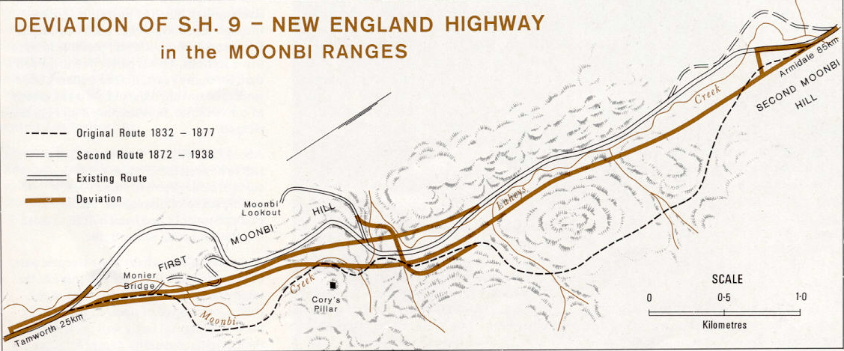
The road generally followed the trail blazed in 1832 by Edward Gostwyck Cory. His feat is commemorated by the balanced lump of granite called Cory’s Pillar (sometimes Cory’s Pillow or Cory’s Nightcap) where he is believed to have sheltered overnight during his explorations.
Difficult ascent, dangerous descent
Before the second route bypassed it in 1872, the main subject of the teamsters’ curses was the feature known as ‘The Pinch’. This was a pass over the First Moonbi Hill near the site of Cory’s Pillar. Although it ran between the highest ridges, it still involved a steep climb of about 200 metres.
So steep was it, in fact, that teamsters used to pool their horsepower (or bullockpower) to climb the rise. They would camp and wait at the base until they could hitch two or more teams together to haul their waggons up in turn. In the summer, they waited for the cool of night so that both men and beasts could give of their best…and, of course, moonlit nights were particularly helpful.
Coming down the hill loaded, they often dragged felled trees behind them to brake their descent down the precipitous slopes.
“Moonboys”
It is said that the Moonbi Ranges were named after a local aboriginal tribe. However, the “Moonbi” name may have been coincidentally reinforced by a custom the teamsters are said to have had. On those nights when the moon would rise, the first man to spot its glow over the hills would call out “moon boys!” as a signal to hitch up for the night’s ascent. Possibly, knowing the local name, they developed the custom out of a sense of humour.
Early improvement
During 1859, tenders were called for clearing, draining and ballasting and the erection of culverts on the Great Northern Road near Tamworth and Moonbi Village and Moonbi Pass. Later, the tender of William Dowel for the Tamworth work and of John Cock, a Tintinhull farmer, for the Moonbi work, were accepted.
The estimates of 1860 included £1,000 to be spent on the “Bendemeer Tamworth Road.” As a result, Capt. B. H. Martindale (Commissioner for Internal Communication) in his fourth report in 1860 was able to refer to “2 miles of road at the Moonbi’s Pass which has been greatly improved”.
Work began in 1863 on metalling the Great Northern Road. By 1865, the section between Tamworth and Bendemeer had been cleared and fenced while that between Bendemeer and Armidale was partly metalled.
Road contractors for this section included Thomas Hobbs, and members of his family. Some local residents can apparently remember a very dedicated Mr. Cavanagh who, around the year 1900, had the care of the road between Moonbi and Bendemeer. At various points along the road he had made tracks leading to the hills, along which he could wheel his barrow to get supplies of small stones to fill up holes in the road. It is said he would lovingly sweep the road surface with a broom!
Where “The Pinch” was blue
Since “The Pinch” was the most difficult section of the route, the original metalling was confined to that part and it extended for about 400m from the bottom. Most of the metalling consisted of small knapped (hand-broken) stonework, but a foundation of larger stones was laid on the steepest section. These were of basalt and no record of where they were obtained has been traced. Because of their blackish-blue colouring, they contrasted with the lighter tones of their surroundings, and consequently, this section was sometimes called “The Blue Pinch”.
“Fossils” of a road
Even though much of the original route through the Moonbis has been abandoned for over a century, it is still possible to trace some sections. This is partly due to the fact that, for many years, timber-getters and stockmen travelled the old path as a matter of convenience, thus keeping it more or less cleared.
About half-way up “The Pinch”, there are still to be seen the remains of a wooden culvert, some pieces of stonework, a hand-packed retaining wall and two logs that presumably had been placed to mark the way and confine the traffic.
Just north of the culvert is the steepest part of the pass. Here there are still some of the table drains built along both sides of the road. Constructed of squared basalt slabs, the drains are still fairly well preserved in their original positions, except for some places where scouring has undermined them. The drains continue up the pass for about 40m to where the road crosses a gully that is one of the sources of Moonbi Creek. There was no bridge across this gully, but filling stones had been placed in it.
At the top of “The Pinch”, the road reverts to its northerly direction and, although the grade for this last 100 metres is fairly gentle, the road is very badly eroded and bears only little evidence of ever being metalled.
The “S-Bend” Deviation
Early in the 1870’s, a second route was found through the Moonbis. This eliminated the steep and daunting climb of “The Pinch”, but produced a sharp S-bend snaking through the hills.
The date of the original survey for what became known as the “S-Bend” deviation is not known, however it may have been one of the several roads surveyed in 1869. We do know that George Loder surveyed the road from Moonbi to Bendemeer between 25 June and 9 July 1879. In that survey, he marked the Blue Pinch as “Old Road”, while the “S-Bend” route is shown as in existence.
The “S-Bend” deviation left the road leading to “The Pinch” about 400 metres up Moonbi Creek from the present highway. The place where it forded Moonbi Creek was probably at or near the Monier Bridge (see below). After two difficult “S-bends”, it followed the course of the present highway.
A bridge that now goes nowhere
A notable feature of the old route is the Monier bridge over Moonbi Creek. Built of concrete blocks, this single span arch bridge is thought to have been built shortly before World War 1, but records of its design and construction appear to have been lost. Any information from our readers would therefore be appreciated. The name appears to perpetuate the N.S.W. State Monier Works or the Frenchman, Joseph Monier (1823-1906), who late last century pioneered new techniques in concrete casting and reinforcing.
The wooden handrails of the bridge’s 10m length are now gone, but the basic structure seems sound and it should stand for many more years, providing it is not damaged by “off-road” vehicles.
A matter of names
In May 1929, the Great Northern Road, from Wisemans Ferry to the Queensland border west of Tenterfield, was renamed the Great Northern Highway. [Authors note: This sentence is incorrect – other DMR sources show it was the road from North Sydney to Mt Lindesay that was renamed] The section from Hexham north to the Queensland border retained that name until on 24 March 1933 it was renamed the New England Highway, as the major through route between the central coast, the New England tablelands and Queensland.
Another deviation
A new route to eliminate the earlier “S-Bend” deviation and a steep grade on a 7 mile (11.2km) long section was built north from the village of Moonbi and was opened on 3 February 1937. The whole work costing approximately $37,000 including $7,000 for “tar surfacing”.
The major portion of the work was carried out by Cockburn Shire Council by “day labour”, that is, using their own workmen under the supervision of the Shire Engineer. The section at the foot of the Range was constructed by Messrs. Fretus and Jenkins under contract to the Council and at a contract price of £5,506.9s.10d.
Further improvements have been undertaken over the years, including the provision of a third lane to allow faster vehicles to pass slower ones negotiating the steep climb.
Route number four
With aerial photography and associated photogrammetric methods, surveying and map-making are both faster and more accurate than in the past. Modern machinery and methods also allow major construction that would at one time have been too difficult and expensive to contemplate. Together, these factors have permitted the planning and the current execution of a greatly improved fourth route through the Moonbis.
The First Moonbi Hill, due to its very rugged character, has always been more notorious than the Second Moonbi Hill. It was on the First Moonbi Hill that reconstruction began in June 1975 and continues now on a 5km section, from approximately 25km to 30km north of Tamworth. Plans are in hand for the continuation of the work over the Second Moonbi Hill.
The timing of this work is, of course, dependent on the continuing availability of funds. As a declared National Highway, the New England Highway is now funded throughout its length by the Commonwealth Government. This fact recognises its importance as an interstate trade artery. Movement along the New England Highway is not just between New South Wales and Queensland, but through its connection with the Oxley Highway and thereby to the Newell and Barrier Highways, it provides a link for traffic going to and from South Australia, Victoria and Western Australia, as well.
At present, work is at an advanced stage on the two sections that make up the whole of the First Moonbi Hill roadworks. The first section involves the construction of new northbound and southbound carriageways from 24.8km to 27.6km north of Tamworth. The second stage entails the construction of a new southbound carriageway from 27.6km to 30.05km, and the reconstruction of part of the existing highway to improve and incorporate it as the northbound carriageway of the new route.
Taking care
The Department undertook an environmental impact study before construction work commenced and, as much as it can, it has tried to avoid changing the natural ecology of the region in any way. Trees and undergrowth are being left undisturbed except where their removal is absolutely necessary for construction or safety reasons. Such plant life keeps the soil stable and provides food and shelter for animal life as well. Native trees and plants also bring colour and variety to the traveller’s eye. Planting and landscaping will be undertaken by the Department to restore those parts which have been affected in any way by the roadworks.
Preserving the past
The same care is being taken with those relics which remain to remind us of the pioneers of our past. The landmark of Cory’s Pillar has been left untouched. In fact, while blasting and other heavy work was carried out in that vicinity, the Pillar was supported with sandbags to hold it in place and protect it from possible damage.
Most of “The Pinch” itself remains unaffected for future generations to explore and study, although the new southbound carriageway cuts through at one point.
Unfortunately, it has also been necessary to locate a short section of the northbound carriageway across part of the old “S-Bend” deviation. But, again, the major point of interest – the Monier Bridge – will not be affected.
A happy medium
Generally, in major road improvements, the aim is to reduce the grades and smooth out the curves. The material which is excavated from the ridges and peaks is often used to fill in the low areas between them, thus averaging out the extremes of grade. As a result of these aims, most of the new route through the Moonbis will be a pleasant path of sweeping curves and moderate grades.
The Department is keenly aware that steep climbs are costly to road users, both in terms of fuel consumption, and increased vehicle wear. On the other hand, steep descents can be dangerous, as gravity adds impetus to a freely-moving vehicle. Experienced drivers know how insidiously speed builds up on a downhill run. The less experienced, however, need to be protected.
Consequently, on the new work the average grade will be 5%, although on the northbound carriageway a short 600m length will be 9.6% and on the southbound carriageway a 725m length will be 9.4%.
To counteract, at least in part, the dangers of brake failures and other similar emergencies, three safety ramps are being built on this First Moonbi Hill section.
Culvert crossings
Extensive drainage operations on the work include a large box culvert at Moonbi Creek under both carriageways. This culvert will be 52m long with three 2.4m X 2.4m cells.
Another culvert at 28.6km on the northbound carriageway is already finished An extension ot the Lahey’s Creek culvert 29.8km from Tamworth is also being built. A total of 1230m³ of concrete will be used in the major culverts.
Massive earth moving
The line up “The Pinch” is still a worthy adversary of man the road builder, although the fight was harder in the old days of pick, shovel and animal power.
In the current work at the First Moonbi Hill, over 400,000m³ of earth and rock will eventually be moved, using both mechanical and explosives techniques. The biggest single cut on the project involves the removal of 94,000m³, the vast majority of this material being solid granite. This is to make a cut 19m deep for the southbound lanes.
The hard granite is still not easy to move and over 100 tonnes of ammonium nitrate and fuel oil mix, with gelignite boosters, will be needed to shift 182,000 tonnes of material.
At the present time there are over 20 major items of plant and equipment, valued at about $1,250,000, operating on the site, some belonging to the Department and some hired. These include a variety of dozers, loaders, graders and large rollers of different types, as well as auxiliaries as air compressors and pneumatic drills, small rollers and concrete mixers.
A considerable concentration of technology and expertise has been brought to bear in this latest round to subdue the mighty Moonbis – a legendry locality in our pioneering past and a formidable obstacle in our continuing quest for better roads.
The task of giving today’s road users and up-to-date, safe, fast and dependable way through this notorious range is the biggest, toughest and most expensive job ever undertaken by the Department in its North Eastern Division, centred at Tamworth. When it is finished it will $5,000,000 very well spent.