GHOST ROADS OF SYDNEY
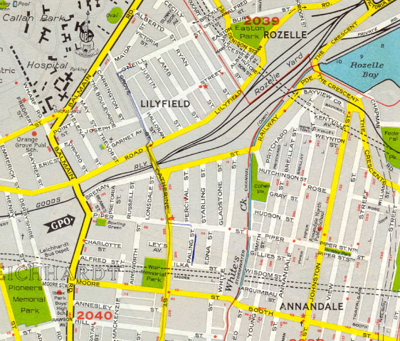
A scan of a 1973 UBD Street Directory of Sydney, showing proposed F3 (North Western) and F4 (Western) Freeways, as well as the Johnstons Creek Route. The sections of these proposed roads shown on this map were never constructed - they were abandoned by the Wran Government in 1977.
This is the page I have created to showcase the unbuilt legacies of Sydney's road planning, those freeway extensions that were touted but later abandoned and some corridors that remain unused to the this day. Please scroll down as I explain the story behind Sydney's road planning - each featured road will have a history of its proposals and photos to show where it would have gone.
Background - Sydney's Road Planning History
The County of Cumberland Planning Scheme was New South Wales ’s first attempt at comprehensive and coordinated town planning. The initiative was one of the Commonwealth Government who recognised the need to adequately plan for the predicted rapid post-war growth. Thus, in June 1947, the Cumberland County Council was inaugurated by State Parliament to prepare a scheme for guidance and control of growth in the County.
Road planning had already been commenced by the Department of Main Roads, firstly in August 1938 and then from a fresh start in 1943, so a comprehensive plan for the development of main roads in the County had been prepared. The 1945 report - ‘The County of Cumberland Main Road Development Plan’ - was incorporated with little alteration into the Cumberland County Council’s plan in 1948. The plan was exhibited in 1951 and became law on 27 June 1951 . The Department of Main Roads’ publication The Roadmakers speaks of road planning and the County of Cumberland Planning Scheme :
“The Metropolitan plan of the Cumberland County Council was not greatly different in general extent and with reference to general land use, from the outline plans provided by the Department. Consequently the Department’s road planning required little alteration before being incorporated in the Council’s plan. The Department’s plan for the development of the Sydney Metropolitan Area had recognised that the existing Main Roads system, even after the completion of earlier planned road widening schemes, was not adequate for future traffic needs, and it therefore included provision for construction of a number of expressways as well as additional surface streets. Some existing streets were to be linked with others to provide through routes, some were to be widened by realignment, while others were to be re-routed.
The freeways with their limited access, were intended to relieve the principal routes of long-distance through traffic. A major factor in fixing the location of freeways was the avoidance of severance of residential area and it was expected that the redevelopment of urban areas requiring renewal could be achieved, in part, as a compliment to construction. In some instances, freeways were located to pass through areas not served by railways and where improved bus service along new routes, at least temporarily, could answer the need for public transport.
The County of Cumberland Planning Scheme did not include detailed planning of the CBD of the City of Sydney , nor did it show roads within that area. However, a complementary road layout for the central areas was adopted by the City of Sydney Planning Conference to provide a continuous network. The road plans for this area provided that the principal radial roads fed traffic into and inner ring of distributor roads around the central business district, which in turn, distributed vehicles into the City. The Main Roads Development Plan for the County of Cumberland then comprised 960 miles of Main Roads or future Main Roads of which 87 miles were planned to be freeways.”1
“The rapid increase in population and traffic in the 1950’s was significantly greater than expected and it became evident that the expansion of the Main Roads System only to the extent that it was previously planned was inadequate if the demands of traffic were to be met. At the time, the target in road planning, overseas as well as in Australia , was a system to cater substantially for full demand. Subsequently, the growth of traffic was so great that it was realised such a target was neither practicable nor in the best interests of the community as a whole. However, at that stage, provision was made for some increased capacity in a number of the freeways. In addition, the location of freeway routes was extended beyond the boundaries of the County of Cumberland , south to Wollongong and to the near South Coast , north to Newcastle and southwest as a relief to the Hume Highway . The early planning of these extensions has proved of great value in view of the expansion of Sydney and Newcastle .”2
However, the pressure of an increasing demand for land was taking its toll on the Department of Main Roads’ proposed ‘County Roads’. The State Government requested that the Department review its construction and priorities with a view to eliminating the least necessary road reservations. Proposed County Roads were divided into three categories, with the many of the reservations from the third category being eliminated during the 1960s. Further pressures from the State Government meant the Department also had to curtail a number of second category County Road proposals. However, all was not lost on the road planning front. One example of shrewd planning was the acquisition of a wide strip of land, that had been released from the Green Belt, alongside the Hume Highway at Bass Hill that would not only provide sufficient room for a six-lane divided highway but allow the planting of trees as part of the Remembrance Drive .
In 1962 it was announced that a new State Planning Authority would be established to replace the Cumberland and Northumberland County councils, and control town planning across the state. A new planning vision for the Sydney region was released in 1968, called the ‘Sydney Region Outline Plan’. Learning from the mistakes of the County of Cumberland Planning Scheme the Sydney Region Outline Plan abandoned the Green Belt-Satellite City concept in favour of linear development. Unlike the County of Cumberland Planning Scheme before it, he plan was never made law, allowing greater flexibility and change but much less control over planning in the Sydney region. This change from a legally enforced metropolitan plan to one based on 'objectives' and 'principles', without the detail that the County Plan had prided itself on, saw a drastic change in the way roads were planned. The one-off plan for the future of Sydney's road needs had already been completed and new road corridors were only gazetted either just prior to construction or at the time when a new chunk of land was released for urban development.
The latter situation is what spawned the road systems of western Sydney (west of Toongabbie) and south-western Sydney (Glenfield-Campbelltown-Camden). The Sydney Region Outline Plan, while not law itself, had provided for the establishment of 'New Cities' at Campbelltown, Camden and Appin and the supporting infrastructure. Included in this were such roads as the Georges River Expressway, the Smiths Creek Bypass road and a long-term expressway linking Minto with the Princes Highway. A structure plan for the Campbelltown/Camden/Appin New Cities complex was released in 1973 by the State Planning Authority.
Out west, land had been resumed for urban development since the very early 1960s, particularly in the Mount Druitt area where the Housing Commission was constructing a number of new estates. The Sydney Region Outline Plan came out at the same time that major road corridors in the area were incorporated into local planning schemes, particularly Blacktown City Council and Penrith City Council. The F2 - Castlereagh Expressway, the Philip Parkway and the Werrington Arterial were all proposals of this era.
County of Cumberland Planning Scheme (1951) - Unbuilt/Abandoned Road Proposals
- F1 - Warringah Freeway extension from Naremburn to the Wakehurst Parkway, including the 'freeway-ification' of the Wakehurst Parkway
- F3 - North Western and Lane Cove Valley freeways from Darling Harbour to Wahroonga
- F4 - Western Freeway extension from Concord to Ultimo
- F6 - Southern Freeway extension from Waterfall to Ultimo
- F7 - Eastern Freeway
- Southern Distributor
- Blue Gum Creek Route
- Dalwood Holmes Deviation
- Cooks River County Road (also known as Kyeemagh-Chullora Road)
- Eastwood County Road (also been referred to as Silverwater-North Ryde route and Ermington-Epping Rd link)
- Johnstons Creek Route
- Inner West Route (Canterbury to Newtown)
- Liverpool Bypass
- Prospect Arterial
St Marys/Mt Druitt/Rooty Hill urban release areas (1962-1968) - Unbuilt/Abandoned Road Proposals
- F2 - Castlereagh Freeway extension from Winston Hills to Blue Mountains
- Philip Parkway (now integrated into Westlink M7)
- Werrington Arterial
Campbelltown/Camden/Appin New Cities Structure Plan (1973) - Unbuilt/Abandoned Road Proposals
- Georges River Expressway
- Minto to Princes Highway expressway
- Smiths Creek Bypass road
- Wilton-Appin expressway (replaces Broughton Pass)
1. Department of Main Roads; The Roadmakers: A History Main Roads in NSW; 1976; p.204-205
2. Department of Main Roads; The Roadmakers: A History of Main Roads in NSW; 1976; p.205-206