State Route 60 Indian Ocean Drive |
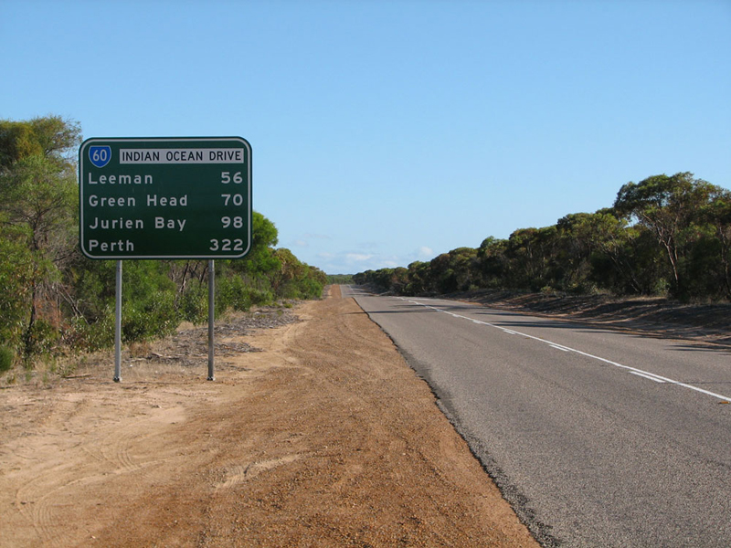
RD sign southbound on Indian Ocean Drive at the intersection with Brand Highway, 31km south of Dongara. Photo taken: March 2011.
Introduced: 1986
Length: 315km
Northern Terminus: Brand Highway & Indian Ocean Drive, 31km south of Dongara
Southern Terminus: Mitchell Freeway, Charles Street & Newcastle Street, West Perth
Route taken: Charles Street, Wanneroo Road, Indian Ocean Drive
Focal Points: Perth, Wanneroo, Lancelin, Cervantes, Jurien Bay, Dongara
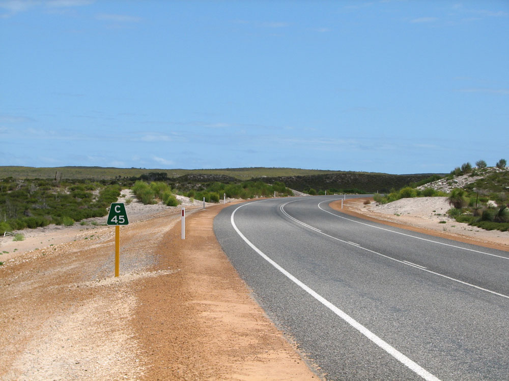
Main Roads Act 1930 classifications: H35 Charles Street/Wanneroo Road, M45 Indian Ocean Drive (Yanchep Beach Road to Cervantes and Leeman to Brand Highway), unclassified (Cervantes to Leeman)
Notable Events:
April
1986 - State Route 60 introduced1
19 September 2010 - Lancelin to Cervantes section opened to traffic2 / State Route 60 extended north from Lancelin to Brand Highway
Description:
State Route 60 is a major radial route leading northwards from Perth alongside the Indian Ocean coast. Originally it was a dead-end route providing access to the popular holiday town of Lancelin, now it provides an alternative route to Geraldton since the completion of the Lancelin - Cervantes road project in 2010. The route essentially has two different parts - from Perth to Wanneroo the route is a major urban arterial road serving the northern suburbs, whilst through traffic uses the Mitchell Freeway. North of Wanneroo, the route is a rural arterial linking Perth with the seaside towns of Yanchep, Guilderton, Lancelin, Cervantes, Jurien Bay, Green Head and Leeman.
State Route 60 commences at the Hamilton Interchange, meeting the Mitchell Freeway, then heading north along Charles Street through Perth's inner northern suburbs. At Dog Swamp, the name changes to Wanneroo Road and the route widens out a generally four-lane, divided carriageway. North of Balcatta, the route takes on a more limited access character as it passes through the suburbs developed in the 1960s and 1970s by the then State Housing Commission. Direct property access is generally limited to the occasional rural property that survives amongst the near continuous urban development. North from Ocean Reef Road, the route again takes on the appearance of a typical urban arterial with direct property access as it passes through Wanneroo townsite.
The four-lane divided carriageway terminates north of Wanneroo at Joondalup Drive and the route changes into a typical rural arterial. Extensive upgrading and realignment in the 1960s and 1970s between Wanneroo and Yanchep has been complemented by two sections of dual carriageway which were constructed at the turn of the century. These sections provide overtaking opportunities and safer turning movements on what is a fairly heavily trafficked section of road. A short, 3km section of winding road amongst the trees remains just south of Yanchep Beach Road, almost as a reminder of what the road looked like in the past.
Traffic volumes drop north of Yanchep Beach Road, however extensive upgrades over the last 10 years have meant that a very high standard single carriageway road now exists to Lancelin. Numerous overtaking lanes have been constructed, along with sealed shoulders and minor alignment improvements. From Lancelin to Cervantes the route was constructed brand new in 2008-2010 and is of a similarly high standard with some beautiful glimpses of the ocean near Wedge Island.
North of Cervantes, to Leeman, the road quality drops slightly, with narrower pavement, no edge lines and no sealed shoulders. This section was built in the late 1990s to a lower design standard and is still (as at February 2012) an unclassified road under the control of Local Government. North of Leeman, the route is again under the control of Main Roads WA, however is of a lower standard as it was constructed over 25 years ago. Just over 30km south of Dongara, the route crosses the Dongara-Eneabba railway and then promptly terminates at the junction with Brand Highway. New signs installed in 2010 at this junction identify State Route 60 as an alternative route to Perth.
History:
Coming soon...
What's in a name?
The section of the route between Yanchep Beach Road and Lancelin townsite was previously known as 'Wanneroo Road' (from Yanchep Beach Road to Gingin Brook Road) and 'Perth-Lancelin Road' (from Gingin Brook Road to Lancelin townsite). In 2010, the section north of Gingin Brook Road to the Lancelin turnoff was renamed Indian Ocean Drive, followed by the section south ot Gingin Brook Road in 2011. Yanchep Beach Road now marks the southern end of Indian Ocean Drive and the northern end of Wanneroo Road.
References:
1. Main Roads Department, Annual Report 1985/86, p. 16
2. Colin Barnett & Simon O'Brien, Last link in Indian Ocean Drive coastal road open, media release, 19 September 2010.

Photos: Charles Street & Wanneroo Road
 |
The southern-most mention of SR60, northbound on Mitchell Freeway at Malcolm Street, West Perth. Note the evening peak period traffic. |
 |
Overhead lane allocation signs northbound on Mitchell Freeway approaching the Market Street and Charles Street/Graham Farmer Freeway exits, West Perth. |
 |
AD sign northbound on the Charles Street off-ramp, approaching the turnoff to the Graham Farmer Freeway, West Perth. |
 |
Trailblazer assembly northbound on the off-ramp to Charles Street, approaching Newcastle Street at West Perth. This is the southern terminus of State Route 60. |
 |
Trailblazer assembly southbound on Charles Street at Newcastle Street, West Perth. Photo taken: October 2010. |
 |
Trailblazer assembly westbound on Bulwer Street (SR72) approaching Charles Street, North Perth. Photo taken: February 2011. |
 |
Charles Street looking south at Bulwer Street, North Perth. |
 |
Trailblazer assembly hidden behind a tree, southbound on Charles Street approaching Bulwer Street (SR72), North Perth. Photo taken: February 2011. |
 |
Charles Street looking north from near Bulwer Street (SR72), North Perth. Photo taken: February 2011. |
 |
Trailblazer assembly eastbound on Balcatta Road, approaching Wanneroo Road, Balcatta. According to MRWA, State Route 77 no longer goes along Balcatta Road, however they certainly haven't updated the signs to show this! Photo taken: May 2010. |
 |
AD sign on the eastbound off-ramp from Reid Highway to Wanneroo Road, Hamersley. Source: Andrew Jones, October 2009. |
 |
Wanneroo Road, looking north from the junction with Reid Highway at Hamersley. Note the last focal point is Lancelin, formerly the 'end of the road'. Photo taken: December 2010. |
 |
Wanneroo Road, looking south at Beach Road, Girrawheen. Photo taken: October 2010. |
 |
State Route 60 trailblazer southbound on Wanneroo Road near Warwick Road, Girrawheen. Photo taken: October 2010. |
 |
ID sign with topknot at the intersection of Wanneroo Road & Warwick Road, Warwick. This sign appears to be a direct replacement of an old direction sign and topknot, dating from the introduction of the State Route system. Whoever replaced the sign has not done their job properly and included the route marker within the sign proper. Photo taken: October 2010. |
 |
Wanneroo Road looking south to the Marangaroo Drive intersection, Marangaroo. Note the trailblazer assembly which correctly shows the short SR60/SR81 duplex between Marangaroo Drive and Warwick Road. Photo taken: October 2010. |
 |
Wanneroo Road looking north at Parin Road, Marangaroo. Photo taken: October 2010. |
 |
Trailblazer assembly northbound on Wanneroo Road at Hepburn Avenue (SR82), Madeley. Note that despite the recent extensions of Hepburn Avenue to Alexander Drive and then Beechboro Road, SR82 has not been extended. Photo taken: November 2010. |
 |
Wanneroo Road looking north at Kingsway, Madeley. Photo taken: October 2010. |
 |
AD sign northbound on Wanneroo Road, approaching Gnangara Road (SR83) at Wangara. Note that this sign incorrectly omits SR83 straight ahead. Photo taken: November 2010. |
 |
Trailblazer assembly southbound on Wanneroo Road at Gnangara Road, Wangara. Note the arrow is pointing right instead of left! Photo taken: November 2010. |
 |
Trailblazer assembly southbound on Wanneroo Road at Whitfords Avenue, Wangara. Note that these signs correctly show that SR83 goes both right and straight ahead. Photo taken: November 2010. |
 |
Trailblazer assembly northbound on Wanneroo Road at Ocean Reef Road (SR84), Wangara. Photo taken: November 2010. |
 |
Trailblazer assembly with incorrectly coloured arrow and 'END' tabs, eastbound on Ocean Reef Road at Wanneroo Road, Wangara. Photo taken: November 2010. |
 |
Wanneroo Road looking south at Celestine Street, Wanneroo. Photo taken: October 2010. |
 |
State Route 60 trailblazer with incorrect font, southbound on Wanneroo Road at Hastings Street, Wanneroo. Photo taken: October 2010. |
 |
Wanneroo Road looking north towards Pinjar Road, Sinagra. Pinjar Road is the original alignment of the now-decommissioned State Route 86, which explains why these trailblazers are at this otherwise unimportant intersection. |
 |
ID sign facing southwestbound traffic at the intersection of Wanneroo Road & Pinjar Road, Sinagra. Pinjar Road is the original alignment of the now-decommissioned State Route 86, which explains why this ID sign is at this otherwise unimportant intersection. Photo taken: November 2010. |
 |
Wanneroo Road looking north towards the new alignment of Pinjar Road, only a few hundred metres north of the old intersection shown in the previous two photos. This realignment of Pinjar Road was under construction when this photo was taken. Photo taken: November 2010. |
 |
Wanneroo Road southbound approaching Joondalup Drive at Carramar. Joondalup Drive provides the northernmost link between Mitchell Freeway and Wanneroo Road. Photo taken: December 2010. |
 |
RD sign northbound Wanneroo Road near Joondalup Drive, Carramar. Note that Lancelin is the last focal point - no mention of Geraldton yet. Photo taken: November 2010. |
 |
Wanneroo Road southbound just south of Flynn Drive, Carramar. This sign is no longer correct as the dual carriageway has now been extended north to Joondalup Drive, approximately 2km south. Previously it ended near Wallawa Street, Ashby. Photo taken: December 2010. |
 |
Wanneroo Road looking south near Menchetti Road, Neerabup. Note the dual carriageway section which ends in the distance. Photo taken: December 2010. |
 |
Wanneroo Road looking south at Hester Avenue, Neerabup. Hester Avenue is at present the only link between Wanneroo Road and the cost, between Joondalup and Yanchep. Note the trailblazer should have a straight ahead arrow as it is placed before the major intersection. Photo taken: December 2010. |
 |
Wanneroo Road looking south near Wattle Avenue, Neerabup, showing the dual carriageway section. Note the service road to the left which was built on the old road alignment. Photo taken: December 2010. |
 |
Wanneroo Road looking south near Nowergup Road, Nowergup, showing the beginning of the dual carriageway section in the distance. Photo taken: December 2010. |
 |
Wanneroo Road looking south through Neerabup National Park, 15km north of Wanneroo. The curving and undulating road alignment is typical of this section of Wanneroo Road and the reason why the two dual carriageway sections have been constructed to provide safe overtaking opportunities. Photo taken: December 2010. |
 |
Wanneroo Road looking south at Carabooda, approximately 17km north of Wanneroo. Note the old pavement to the left - the section of Wanneroo Road from Carramar to Carabooda was extensively realigned during the 1970s and 1980s. Photo taken: December 2010. |
 |
Wanneroo Road looking south at Karoborup Road North, Carabooda. Note the dual carriageway section providing overtaking opportunities between the lower standard sections of road. Photo taken: December 2010. |
 |
Wanneroo Road looking south at Bernard Road South, Carabooda, approximately 21km north of Wanneroo. Photo taken: December 2010. |
  |
Two photos of Wanneroo Road, looking south through Yanchep National Park, showing a lower standard section of road, between 21 and 25km north of Wanneroo. Photos taken: December 2010. |
 |
RD sign southbound from the junction of Wanneroo Road, Indian Ocean Drive & Yanchep Beach Road in Yanchep National Park. Photo taken: December 2010. |
Photos: Indian Ocean Drive
 |
RD sign northbound on Indian Ocean Drive after the junction with Yanchep Beach Road, Yanchep National Park. Photo taken: March 2011. |
 |
Indian Ocean Drive northbound approaching Gingin Brook Road, 79km north of Perth. This is a terribly designed AD sign and I suspect that beneath the coverplate is 'VIA INDIAN OCEAN DRIVE' which is a tautology given the use of the road name patch. Note the first mention of Geraldton on northbound signage. Photo taken: March 2011. |
 |
ID sign assembly at the intersection of Indian Ocean Drive & Gingin Brook Road, Neergabby. Note that the left-pointing sign refers to Indian Ocean Drive rather than Wanneroo Road, despite this photo being taken prior to the official name change. Photo taken: March 2011. |
 |
Southbound AD sign on Indian Ocean Drive, approaching Gingin Brook Road. Note the dodgy coverplate on the upper panel and the incorrect use of upper case for 'Brand Highway'. Photo taken: March 2011. |
 |
Indian Ocean Drive looking north near the junction with Gingin Brook Road. This is the first RD sign to show Geraldton. Photo taken: March 2011. |
 |
Indian Ocean Drive looking west towards Sovereign Hill Drive, 84km north of Perth. Sovereign Hill is typical of many rural residential estates scattered along the route between Yanchep and Lancelin. Photo taken: March 2011. |
 |
Indian Ocean Drive looking east from the Guilderton turnoff, showing both RD and kilometre plate signs. Photo taken: March 2011. |
 |
ID sign assembly at the intersection of Indian Ocean Drive & Guilderton Road, Gabbadah. Note how the signs pointing down Guilderton Road don't actually refer to Guilderton - this is not unusual in WA. Photo taken: March 2011. |
 |
RD sign northbound on Indian Ocean Drive at Gabbadah. This sign pre-dates the opening of the Lancelin-Cervantes project and therefore shows Lancelin as the end of the road. Photo taken: March 2011. |
 |
Indian Ocean Drive looking south between the Guilderton and Seabird turnoffs, 90km north of Perth. Photo taken: March 2011. |
 |
RD sign on Indian Ocean Drive, southbound near the Seabird turnoff. Photo taken: March 2011. |
 |
Indian Ocean Drive looking north towards Seabird Road, 93km north of Perth. Photo taken: March 2011. |
 |
Sign assembly at the intersection of Indian Ocean Drive & Seabird Road. Note again no reference to Seabird, and also the obsolete name plate showing the old road name: 'Perth - Lancelin Road'. Photo taken: March 2011. |
 |
RD sign northbound from the Seabird turnoff, again showing Lancelin as the end of the road. Photo taken: March 2011. |
 |
Indian Ocean Drive looking north, 25km south of Lancelin, showing typical winding section between Seabird and Lancelin. Photo taken: March 2011. |
 |
Another northerly view of Indian Ocean Drive through the sand hills, this time 21km south of Lancelin. Photo taken: March 2011. |
 |
RD sign southbound on Indian Ocean Drive near Ledge Point Road, 13km south of Lancelin. Photo taken: March 2011. |
 |
Indian Ocean Drive looking north towards the Ledge Point turnoff, 13km south of Lancelin. Photo taken: March 2011. |
 |
Sign assembly at the intersection of Indian Ocean Drive & Ledge Point Road, again showing the old road name: 'Perth - Lancelin Road'. Photo taken: March 2011. |
 |
RD sign northbound on Indian Ocean Drive near the Ledge Point turnoff. Note that Lancelin is only 12km away yet not mention of any towns beyond the former 'dead end'. Photo taken: March 2011. |
 |
Indian Ocean Drive looking north, 10km south of Lancelin. Note the rural residential development at Karakin in the background. Photo taken: March 2011. |
 |
RD sign southbound on Indian Ocean Drive near KW Road, Karakin. Photo taken: March 2011. |
 |
Sign assembly at the intersection of Indian Ocean Drive & KW Road. KW Road provides an east-west link between Brand Highway near Regans Ford and the coast. Photo taken: March 2011. |
 |
Indian Ocean Drive looking north towards Lancelin from KW Road, showing the long weekend platoons of traffic heading north. Photo taken: March 2011. |
 |
RD sign northbound on Indian Ocean Drive near KW Road. Again note no mention of any destinations beyond Lancelin - this sign pre-dates the completion of Indian Ocean Drive in 2009. Photo taken: March 2011. |
 |
New RD sign, installed as part of the Lancelin-Cervantes road project, southbound near the Lancelin turnoff. Note the use of the old road name 'Lancelin Road' - this sign is yet to be updated following the name change in March 2008. Photo taken: March 2011. |
 |
AD sign northbound on Indian Ocean Drive approaching Lancelin Road near Lancelin. Lancelin Road is the original alignment of State Route 60 - prior to the completion of the Lancelin - Cervantes road project in 2010, State Route 60 followed Lancelin Road to terminate at Lancelin. Photo taken: March 2011. |
 |
AD sign westbound on Lancelin Road approaching Indian Ocean Drive. Note the incorrect reference to Lancelin Road - it is now part of Indian Ocean Drive. Photo taken: March 2011. |
 |
AD sign southbound on Indian Ocean Drive approaching Lancelin Road. Again note the incorrect use of Lancelin Road as the road name straight ahead and also the reference to Yanchep rather than Perth. Photo taken: March 2011. |
 |
Heading north from Lancelin Road there is no proper RD sign, only this sign denoting the towns at which services are next available. This sign is located just north of Seaview Drive, 1km north of Lancelin Road. Photo taken: March 2011. |
 |
Indian Ocean Drive looking south, 20km north of Lancelin. Photo taken: March 2011. |
 |
Indian Ocean Drive looking north towards the turnoff for Nilgen Lookout within Nilgen Nature Reserve, 22km north of Lancelin. There are some nice views along this section of the route as you climb through the sand hills. Photo taken: March 2011. |
 |
Another northerly view along Indian Ocean Drive, 24km north of Lancelin. Photo taken: March 2011. |
 |
Indian Ocean Drive looking north, 45km south of Cervantes. Photo taken: March 2011. |
 |
A southerly view of Indian Ocean Drive from a small roadside parking area, 42km north of Lancelin/43km south of Cervantes. Note the platoon of long weekend holiday traffic. Photo taken: March 2011. |
 |
The first real glimpse of the Indian Ocean on Indian Ocean Drive; this view is looking north 40km south of Cervantes near the Wedge Island turnoff. Photo taken: March 2011. |
 |
Indian Ocean Drive looking south, 50km north of Lancelin/37km south of Cervantes. Note the cuttings through the sand hills are quite visible. Photo taken: March 2011. |
 |
Typical WA fingerboard sign showing only focal points and distances - no route marker or road name - at the turnoff to Hangover Bay, 14km south of Cervantes. Photo taken: March 2011. |
 |
Indian Ocean Drive southbound approaching the turnoffs to The Pinnacles (left) and Hangover Bay (right), 14km south of Cervantes. Photo taken: March 2011. |
 |
Services signage for southbound traffic as you leave Cervantes. Note the incorrect distance for Yanchep - that is actually the distance to Perth! Photo taken: March 2011. |
 |
RD sign southbound on Indian Ocean Drive at Cervantes. Note the correct distances for both Yanchep and Perth. Photo taken: March 2011. |
 |
Well designed AD sign northbound on Indian Ocean Drive approaching the southern junction with Cervantes Road. Photo taken: March 2011. |
 |
A northerly view of the intersection of Indian Ocean Drive & Cervantes Road showing brand new ID sign assembly. Photo taken: March 2011. |
 |
ID sign assembly facing eastbound traffic at the intersection of Indian Ocean Drive & Cervantes Road, Cervantes. Photo taken: March 2011. |
 |
AD sign southbound on Indian Ocean Drive approaching Cervantes Road. Note no reference to Perth, only Lancelin. Photo taken: March 2011. |
 |
AD sign northbound on Indian Ocean Drive approaching the northern junction with Cervantes Road. Note the incorrect use of upper case letters for 'Brand Highway'. Photo taken: March 2011. |
 |
AD sign westbound on Cervantes Road approaching Indian Ocean Drive at Cervantes. Photo taken: March 2011. |
 |
AD sign southbound on Indian Ocean Drive approaching Cervantes Road. Photo taken: March 2011. |
 |
RD sign northbound on Indian Ocean Drive as you leave the junctions with Cervantes Road. In April 2011, this wss the last mention of SR60 for over 120km until you reach the Brand Highway junction! New signs showing SR60 have since been erected at Coolimba. Photo taken: March 2011. |
 |
Typical view of Indian Ocean Drive between Cervantes and Jurien Bay - looking north near Molah Hill Lookout, approximately 10km north of Cervantes. Photo taken: March 2011. |
 |
Indian Ocean Drive looking south near Fatfield Estate, 12km north of Cervantes. Photo taken: March 2011. |
 |
Services signage northbound as you approaching Jurien Bay from Cervantes. Photo taken: March 2011. |
 |
RD sign for southbound traffic leaving Juerin Bay. Note no mention of State Route 60 or any destinations beyond Cervantes - this sign probably dates from construction of the Cervantes - Jurien Bay link in 1997. Photo taken: March 2011. |
 |
Indian Ocean Drive (Bashford Street) looking north on the southern outskirts of Jurien Bay. Photo taken: March 2011. |
 |
Indian Ocean Drive (Bashford Street) looking southwest through Jurien Bay town centre. Photo taken: March 2011. |
 |
Indian Ocean Drive looking north towards the junction with Jurien Road, just north of Jurien Bay townsite. Note that this signage has not yet been replaced to include reference to State Route 60. Photo taken: March 2011. |
 |
AD sign, dating from the completion of the Jurien Bay to Cervantes link, westbound on Jurien Road approaching Indian Ocean Drive. The brown sign in the background refers to Nambung National Park and the Pinnacles. Photo taken: March 2011. |
 |
Indian Ocean Drive looking south near the Sandy Cape National Park turnoff, 10km north of Jurien Bay. Photo taken: March 2011. |
 |
Indian Ocean Drive looking north at The Lakes Way - the southern entrance into the tiny village of Green Head. Indian Ocean Drive bypasses Green Head only a kilometre or two to the east. Photo taken: March 2011. |
 |
Older ID sign at the intersection of Indian Ocean Drive & Coorow-Green Head Road, Green Head. Photo taken: March 2011. |
 |
Indian Ocean Drive looking south at Greenhead Road, the northern access road into Green Head. There seems to be some confusion on both road signs and maps as to the correct spelling of Green Head. Photo taken: March 2011. |
 |
Non-standard and poorly-designed AD sign southbound showing that Green Head has been bypassed by Indian Ocean Drive. Note the use of 'Greenhead' which matches the road name but not other signage referring to the village. Photo taken: March 2011. |
 |
Services signage northbound on the southern approach to Leeman, 7km north of Green Head. Photo taken: March 2011. |
 |
Indian Ocean Drive looking south at Ruddock Street in the village of Leeman. There isn't much other than this roadhouse, a handful of small shops and a few hundred house, most of which are located off the main road. Photo taken: March 2011. |
 |
Between Leeman and the Brand Highway, Indian Ocean Drive passes quite close to the ocean giving some spectacular views such as this one. This photo looks north, 2km north of Leeman. Photo taken: March 2011. |
  |
Old and new RD signs southbound on Indian Ocean Drive at Coolimba. The newer sign omits Green Head in favour of Perth, which is inconsistent with the newly installed RD sign after the Brand Highway junction. Top photo: March 2011. Bottom photo: March 2012. |
  |
The top photo shows an old black AD sign northbound on Indian Ocean Drive approaching the junction with Eneabba-Coolimba Road at Coolimba. In April 2011, this sign was replaced by the brand new AD sign shown in the bottom photo, which now shows SR60. Top photo: March 2011. Bottom photo: March 2012. |
  |
The top photo shows a black ID sign assembly at the intersection of Indian Ocean Drive & Eneabba-Coolimba Road. Note how the legend Leeman is out of alignment for some strange reason. Also note reference to 'Greenhead' rather than Green Head and 'Jurien' rather than Jurien Bay. The bottom photo shows the new sign assembly that replaced it in April 2011 - note again the incorrect use of Jurien and the omission of Green Head in favour of Perth. Top photo: March 2011. Bottom photo: March 2012. |
  |
Old black and new green AD signs westbound on Eneabba-Coolimba Road approaching the junction with Indian Ocean Drive at Coolimba. Note the design error in the new sign - there should not be a dividing line between the two panels as that suggests that SR60 and Indian Ocean Drive are for the left turn only. Top photo: March 2011. Bottom photo: March 2012. |
  |
Old and new AD signs southbound on Indian Ocean Drive approaching Eneabba-Coolimba Road. Note the omission of Green Head in favour of Perth on the new sign. Top photo: March 2011. Bottom photo: March 2012. |
 |
New RD sign northbound on Indian Ocean Drive at Coolimba. Prior to 2011, there was no RD sign at this location. Photo taken: March 2012. |
 |
Indian Ocean Drive looking south approximately 17km north of Leeman, showing glimpses of the Indian Ocean. Photo taken: March 2011. |
 |
Indian Ocean Drive looking north alongside the Indian Ocean, 30km north of Leeman. Photo taken: March 2011. |
 |
Indian Ocean Drive looking south, 40km north of Leeman. Photo taken: March 2011. |
 |
RD sign southbound on Indian Ocean Drive near the junction with Brand Highway at Arrowsmith, 56km north of Leeman. Photo taken: March 2011. |
 |
ID sign assembly at the intersection of Brand Highway & Indian Ocean Drive, Arrowsmith. Note the black ID sign which was not replaced during the recent replacement of signs at this junction. Photo taken: March 2011. |
 |
AD sign northbound on Brand Highway approaching Indian Ocean Drive, Arrowsmith. Note the coverplate - I assume the sign designer had originally omitted reference to Dongara. Photo taken: March 2011. |
 |
Brand new AD sign southbound on Brand Highway approaching the junction with Indian Ocean Drive. Note the poor design with the route marker next to the road name instead of between arrow and focal point. Photo taken: March 2011. |
 |
Older AD sign pre-dating the completion of the Lancelin-Cervantes road project, southbound on Brand Highway approaching Indian Ocean Drive at Arrowsmith. Photo taken: March 2011. |
Old alignment: Lancelin

Originally, State Route 60 terminated at Lancelin as this was the 'end of the road' heading north from Perth. Until 2010, the only vehicle access north of Lancelin towards Cervantes was a four-wheel-drive track through the sand dunes to Wedge Island.
Documentation and maps relating to State Route 60 simply showed the northern terminus as 'Lancelin'. It is unknown whether this referred to the boundary of the townsite, or the logical terminus at the Gingin Road/Walker Avenue intersection. As far as I am aware, there has never been any State Route signage within Lancelin to provide some certainty to either argument.
Upon opening of the Lancelin - Cervantes road project in 2010, State Route 60 was re-routed onto this new road and extended north to the Brand Highway, south of Dongara. The 7km section of the route from Indian Ocean Drive to Lancelin was consequently decommissioned. Photographs on the Expressway website illustrate that reference to State Route 60 entering Lancelin had been removed as early as 2008, in conjunction with the opening of the short section of Indian Ocean Drive from Lancelin Road to Ocean Farms Estate.
 |
Lancelin Road looking west towards Lancelin, approximately 300m west of Indian Ocean Drive. Photo taken: March 2011. |
 |
Lancelin Road looking south near Old Ledge Point Rd on the southern outskirts of Lancelin. Lancelin Road becomes Walker Avenue as it enters the Lancelin townsite. Photo taken: March 2011. |
 |
Walker Avenue looking south near Whitfield Street, Lancelin. Photo taken: March 2011. |
 |
Walker Avenue looking north at Whitfield Street, Lancelin. Photo taken: March 2011. |
 |
Walker Avenue looking southeast at Wadge Avenue, Lancelin. Photo taken: March 2011. |
 |
Walker Avenue looking west to the junction with Gingin Road, Lancelin. This intersection is the assumed original terminus of State Route 60, however as far as I am aware never had any direction signposting. Photo taken: March 2011. |