State Route 87 Burns Beach Road |

AD sign westbound on Burns Beach Road approaching the junction with Mitchell Freeway, Currambine. Photo taken: August 2011.
Introduced: 2008
Length: 5km
Eastern Terminus: Joondalup Drive & Burns Beach Road, Joondalup
Western Terminus: Burns Beach Road & Ocean Parade, Burns Beach
Route taken: Burns Beach Road
Focal Points: Burns Beach, (Mindarie), (Perth), 'To SR60 Wanneroo Road'
Main Roads Act 1930 classification: unclassified
Notable Events:
2008 - State Route 87 introduced
2008 - Burns Beach Road duplicated between Marmion Avenue and Joondalup Drive1
Description:
State Route 87 is a short east-west route in northern Perth, linking the major north-south arterials of Marmion Avenue, Mitchell Freeway and Wanneroo Road (via State Route 85). It was introduced as part of the extension of the Mitchell Freeway from Hodges Drive to Burns Beach Road in 2008, presumably to provide a connection from the new terminus of State Route 2 to the remainder of the network.
Burns Beach Road is a four-lane divided carriageway between Marmion Avenue and Joondalup Drive. West of Marmion Avenue, the route is a lower speed, lower trafficked two-lane single carriageway which ends abruptly at a right-angle bend at Ocean Parade.
History:
Coming soon...
Where's the western terminus:
A route list, provided by MRWA, states that the western terminus of the route is at the junction of Burns Beach Road and Ocean Parade, Burns Beach. However, the AD sign westbound approaching Marmion Avenue does not show State Route 87 continuing west of this junction. In the absence of any other signage along this section of Burns Beach Road, or on Marmion Avenue, it is difficult to determine which is correct. For the purposes of this page, I have assumed that the route list is correct and that the signage is in error.
Signage:
Signage along the route is frankly poor. Of the three junctions with other states routes, only the junction with Mitchell Freeway has the full complement of signs required under the MRWA Guidlines for Direction Signposting. The junctions with Marmion Avenue and Joondalup Drive are missing numerous signs and some of the signs that do exist are missing route markers.
References:
1. Landgate aerial photography, 9/3/2008 and 6/12/2008
|
Photos of State Route 87 - Marmion Avenue to Joondalup Drive |
|
 |
SR87 ID sign incorrectly installed at the junction of Marmion Avenue & Shenton Avenue, Currambine. This sign should, of course, be sited at the junction of Marmion Avenue & Burns Beach Road. |
 |
ID sign, with the SR87 shield, incorrectly installed at the junction of Marmion Avenue & Burns Beach Road. This is the sign that should been installed at the junction with Shenton Avenue. |
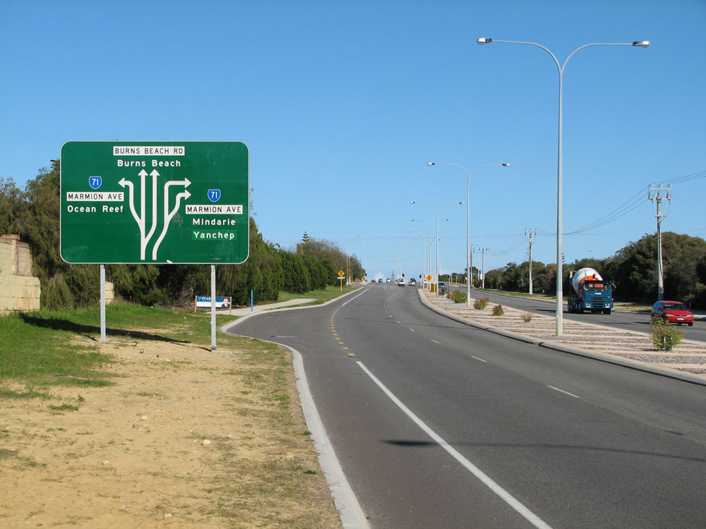 |
AD sign westbound on Burns Beach Road approaching the junction with Marmion Avenue. Note that the sign does not show SR87 straight ahead - this is not consistent with the information from MRWA which gives Ocean Parade as the western terminus. It should also be noted that this sign, and the ID sign above, are the only two direction signs at this junction - not even any trailblazers. This is unfortunately typical of the northern end of Marmion Avenue. Photo taken: August 2011. |
 |
Burns Beach Road looking west from Sunlander Drive towards the roundabout junction with Connolly Drive, Kinross. The bridge crosses a shared path linking Currambine with Kinross. |
 |
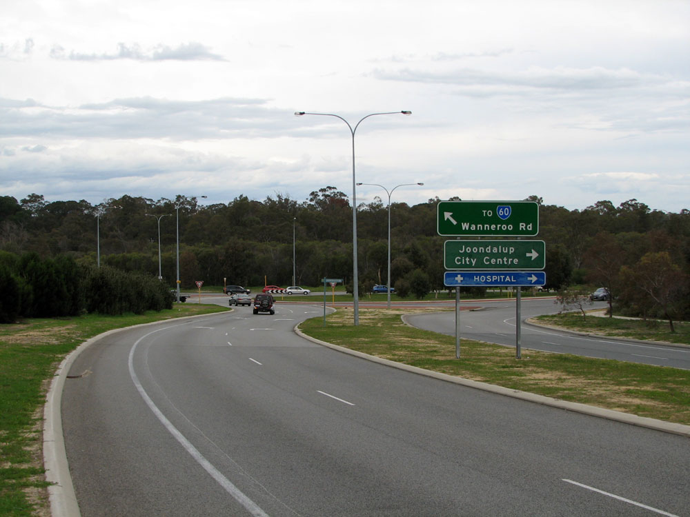
AD sign eastbound on Burns Beach Road approaching the junction with Mitchell Freeway, Currambine. The legend 'TO SR60 Wanneroo Rd' is on a coverplate; I assume covering 'Yanchep/Lancelin'. The coverplate would have been installed when Marmion Avenue was extended to Yanchep, being a shorter route than via Wanneroo Road. Photo taken: August 2011. |
 |
AD sign northbound at the current end of Mitchell Freeway, Currambine. Again note the coverplate which presumably covers 'Yanchep/Lancelin'. Again note there's no mention of Yanchep, which is inconsistent with the ID signs below. Photo taken: August 2011. |
 |
ID signs at the junction of Mitchell Freeway & Burns Beach Road, Currambine. Note that the left-pointing sign was obviously replaced, however the right-pointing sign had to make do with a coverplate that nearly covers the entire signface. |
 |
AD sign westbound on Burns Beach Road approaching the junction with Mitchell Freeway, Currambine. The overbridge carries only the railway line, which is currently (as at February 2012) being extended from Clarkson to Brighton. Photo taken: August 2011. |
Burns Beach Road looking west at Blue Mountain Drive, Joondalup. Photo taken: August 2011. |
|
 |
Burns Beach Road looking east to the eastern terminus of the route - the junction with Joondalup Drive (State Route 85), Joondalup. Note there is no mention of SR85 in either direction, nor any mention of the fact that SR87 ends. Photo taken: August 2011. |
 |
AD sign westbound on Joondalup Drive approaching the junction with Burns Beach Road. While there is an AD sign with correct route numbering in this direction, there are no signs at all approaching this junction from the south. Photo taken: August 2011. |

Last updated 21 June 2012 © Ozroads 2003-2012. |