NEW SOUTH WALES ROUTE NUMBERING:
The Sydney Metroad System

The Metroad system is the most significant navigation development in the history of Sydney's road network. These routes, characterised by their blue and white hexagonal shields, form the basis of navigation into and around Sydney.
Initially the system was rolled out in 1992-93 with Metroad 4 the first route to be fully signed during November/December 1992, the remainder following in 1993. The original Metroads consisted of 6 routes; 1,2,3,4,5 & 7; of which four were radial and two circumferential. During the late 1990's, 3 more routes were added to the system, two circumferential and one radial, Metroad 6 (1999), Metroad 9 (1998) and Metroad 10 (also 1998). In the case of Metroad 6, its promotion from State Route status was delayed until construction of 3 major upgrades/deviations were completed. Metroad 8 has been reserved for future use, most likely as the Western Sydney Orbital.
Upon introduction of the Metroad system, the Roads and Traffic Authority issued brochures informing road users of the new system and how to use it. From a RTA brochure in 1992:
"Basically, the new system involves designating four radial routes and two ring routes as Metroads. These major routes embrace all of Sydney, generally from the Hawkesbury River in the north, the Nepean River in the west and Port Hacking in the south. To emphasise the broad purpose of the scheme, Metroad destination signs will have, wherever possible, a regional focus. Consequently, if you're heading to Sydney or to any one of the six major destinations shown (namely, the North Coast, Northern Beaches, Windsor, Blue Mtns, Canberra or South Coast), all you really need to do is follow the appropriate Metroad number.
Over the next few weeks and starting with Metroad 4, more than 2,500 signs will begin appearing. The complete network is expected to be fully signposted and operating within 12 months."
From RTA News, February 1993:
METROADS UPDATE
Our October 1992 report noted that, at the official launch of the Sydney Metroad System in September, it was announced Metroad 4 would be 'first cab off the rank'. Sydney Region's Traffic Section at Blacktown reports that this route has now been fully signposted between Broadway and Emu Plains.
Metroad 5 followed and is now consistently numbered from Cross Roads, south of Liverpool, to the Western Distributor over Darling Harbour [incorrect statement, as Harris St was only ever signed as 'To Metroad 5', with Metroad 5's offical terminus at Broadway] . This is largely a new major route which takes over the previous role of the Hume Highway and incorporates recently upgraded arterial roads and the M5 Motorway.
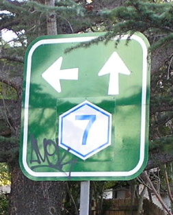
The preparation of signs and route-marker symbols for Metroad 7 (Cumberland Highway) and Metroad 3 (formerly route 33) is well underway and these signs will be installed soon.
Metroads 1 and 2 will follow, with these routes to be signposted later in 1993."
Metroad shields along most routes were first installed as coverplates then replaced with new signs when required, as a lot of the signage was still non-reflective and in the process of being replaced.
However, the Metroad system wasnt just a new route numbering system, it was a complete new style of signposting. Greater emphasis was placed on shields being prominently displayed, making following the numbers easier. Each route was given remote focal points, being a regional destination reached at either end of the route creating a situation where if you were heading to one of the regional destinations you would only need to follow one number. Those remote focal points were:
Metroad 1 -----> Sydney & North Coast & South Coast
Metroad 2 -----> Sydney & Windsor
Metroad 3 -----> South Coast/Hurstville & Northern Beaches
Metroad 4 -----> Sydney & Blue Mountains
Metroad 5 -----> Sydney & Canberra
Metroad 7 -----> South Coast & North Coast
In recent years the Roads and Traffic Authority has decided to change some of the remote focal points as motorists expressed confusion over which places in particular North Coast, South Coast and Northern Beaches were referring to. Signs displaying North Coast and South Coast have now been coverplated/replaced with 'Newcastle' and 'Wollongong' respectively, except on Metroad 7 where 'South Coast' signs have been changed to 'Canberra'.
When Metroad 6 was introduced during 1999, a branch of Metroad 7 was removed from Heathcote Rd, south of Liverpool. Metroad 7 was then re-focused as a Canberra-Newcastle route with the signs changed accordingly. Metroads 3 and 6 have to some extent taken over Metroad 7's former coast-to-coast role, however neither has consistent 'Wollongong' signage north of Metroad 5. Upon entering Sydney on Metroad 1 the first recognition of Wollongong is on the Gore Hill Freeway at Artarmon. This is a practice i really disagree with as it is very important, on a traffic management basis, to keep through traffic away from the City Centre. This could be achieved quite easily with signs along Metroad 3 or 6 showing Wollongong as a focal point.
Follow the links below for more information on each route.....
Metroad 1
Metroad 2
Metroad 3
Metroad 4
Metroad 5
Metroad 6
Metroad 7
Metroad 9
Metroad 10