NEW SOUTH WALES STATE ROUTES
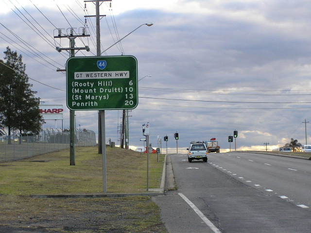
A sample of state route signage in New South Wales on the Great Western Highway at Huntingwood. June 2004.
In this section:
State Routes are the secondary routes of transport, primarily serving intra-state and intra-city traffic. These routes are marked by the blue-and-white upside-down spade shields. New South Wales currently has 40 state routes, although that number was 49 until eight state routes were decommissioned in mid 2004 and State Route 61 was decommissioned in 2005.
Keep reading to discover everything you need to know about New South Wales’ State Route marking system. Information and photos of individual routes can be found by following links in the list below.
In November 1961, the National Association of Australian State Road Authorities (NAASRA) adopted a nationwide policy on the marking of ‘State Routes’. NAASRA envisaged that ‘a state system of route numbering [would] provide for the numbering in the several states and territories of inter-regional and urban routes, additional to those on which National Route marking has been adopted.’
The Department of Main Roads has been investigating the issue of route marking, particularly in the Sydney metropolitan area, since prior to World War 2 and the introduction of National Routes in 1954 and Sydney’s Ring Roads in 1964 were both attempts at solving that problem. However, both systems lacked the ability to mark many of the routes that were later covered in the State Route system.
However, it was not until the early 1970s that a comprehensive system of route marking for the state was established, at the same time as the Department of Main Roads began using aluminium signs, polyurethane paint as backgrounds and computer aided design.
The Department of Main Roads’ 1973 Annual Report mentions that “a system of State Route numbers to compliment the National Route numbers was introduced. The first route to be marked was Trunk Road No. 61 between Orange and Condobolin which was designated State Route 90. Subsequently, the Western Freeway between Wallgrove Road and Emu Plains was marked route F4 and at the same time routes 61 (Liverpool-Eastern Creek) and 69 (Narellan-Windsor) were marked.”
The majority of the remainder of the State Routes were officially introduced in 1974, however some were not fully signposted for a number of years. One example is State Route 88, which was not fully signed until 1980 when a major deviation was opened between Maldon and Wilton. Routes selected as ‘parallelling routes’ - e.g. 44, 60 and 83 - appear to have been very haphazardly introduced, taking as long as 15 years to be fully signed.
The State Route system reached its peak around the late 1980s, before a raft of decommissionings were effected upon introduction of the Metroad route marking system. The first routes to disappear were in 1992/93, including State Routes 11, 33, and 77, followed by routes 14 and 45 in 1998/1999. Other routes were also decommissioned during the 1990s, including routes 12, 17, 50 and 73. For information on decommissioned state routes, see the Decommissioned Routes page.
In 2004, with the seemingly imminent introduction of alpha-numeric route marking in New South Wales, eight state routes were decommissioned. The decommissioning of these routes was one part of an overall plan to introduce alpha-numeric route marking to NSW, a plan which has suffered from a lack of funding.
The most recent State Route to be decommissioned was State Route 61, which bid farewell upon opening of the Westlink M7 in December 2005. However, remnant State Route 61 signage was not completely removed until mid-2006.
How it works - Allocation of Numbers
The Department of Main Roads provided a good explanation of how numbers are allocated to routes in their 1978 publication Interim Guide to Signs and Markings. This publication was formerly available on the RTA website, however has since been removed. A general rule of thumb that applied to all areas was that no State Route would exist with the same number as a National Route in New South Wales, however this rule was broken with the use of State Route 55 (Natioal Route 55 was the Castlereagh Highway) and later State Routes 31, which was a 'downgraded' National Route, and 44.
For the purposes of allocating route numbers, state routes in New South Wales, excluding the former Freeway Route marking system, were divided into three categories - Sydney area, rural areas, and Newcastle & Wollongong.
Sydney area - The system comprises a ring system of routes carrying odd numbers (21 to 75) and a radial system with even numbers (20 to 76). The lower numbers on the ring routes appear closer to the central city and radial routes are numbered in an anti-clockwise direction from north to south around the central city. One interesting pattern that emerged was that odd numbers with the same two digits (e.g. 11, 33, 55, 77) were allocated to the former Ring Roads (i.e. Ring Road 1 became State Route 11 and so on), and that even numbers with the same two digits (e.g. 22, 44, 66) became major radial routes from the CBD.
Country area - Routes in the country area were viewed as an extension of the Sydney system, with the odd-numbered circumferential routes developing into a system of north-south routes (numbered 77 to 99), and the even-numbered radial routes developing into a system of east-west routes (numbered 78 to 98).
Newcastle and Wollongong - The then provincial cities of Newcastle and Wollongong were allocated their own three-digit route numbers - numbers 120 to 149 for the Newcastle region and numbers 150 to 179 for the Wollongong region - working on the same odd (ring) and even (radial) principle as the Sydney system. It is unusual that so many numbers were allocated, given that only a handful of routes were ever signed in Wollongong and probably two handfuls in the Newcastle region.
These rules were generally adhered to, however some exceptions began appearing as early as 1982 (State Route 60 - located in Wollongong, yet uses a Sydney number). A notable exception is State Route 111, which wasn’t even included in the original allocation of numbers, but was introduced in 1989 to replace the former route of National Route 1. I believe 111 was chosen as the number to continue the ‘Highway 1’ theme.
How it works - Paralleling Routes
A small number of State Routes were introduced as ‘paralleling routes’ - basically they replaced bypass lengths of National Routes and were used to service local traffic along the old alignments. Examples include State Route 44 (paralleling route for National Route 32), State Route 60 (paralleling route for National Route 1 through Wollongong), State Route 83 (paralleling route for National Route through the Central Coast), and State Route 89 (paralleling route for National Route 31 from Liverpool to Berrima). Even the Newcastle region got in on the act with State Route 111, which follows the old alignment of National Route 1 through the Newcastle urban area.
How it works - Unsealed Routes
It was general NAASRA and DMR practice not to sign State Routes (or National Routes) along routes that were ‘substantially gravel surfaced’, with the result that State Route 87 only extended as far north as Hillston until the route was fully sealed through to Cobar and Bourke in 2001.
Originally, many routes were signed using topknots so that the Department of Main Roads didn’t need to replace reasonably new signs that were in good condition. Eventually, all route shields were incorporated into directional signs as they were progressively updated - much like what was done with the Metroad system. In addition, new signs installed prior to a route’s official introduction would also be designed with the route shield, only to have it coverplated until the route was introduced.
Trailblazers, in the traditional - cut-out shield - form, were not used on the state route marking system to my knowledge. However, following the introduction of Tourist Drives in the mid 1990s modified trailblazers began appearing, using a standard green rectangle; an upwards arrow; and the State Route and Tourist Drive shields. However, most, if not all, of these signs disappeared by the end of 2004.
-
Department of Main Roads (DMR), Annual Report, 1973
-
Department of Main Roads (DMR), Interim Guide to Signs and Markings, November 1978 (updated to September 1986). Formerly available online from: http://www.rta.nsw.gov.au/doingbusinesswithus/downloads/technicalmanuals/technicalmanuals_dl1.html
-
Personal correspondence with Roads and Traffic Authority
List of active New South Wales State Routes
Indexed in numerical order
Gold Coast Highway |
|
North Ryde to Dee Why Dehli Road, Fullers Road, Boundary Street, Warringah Road |
|
Sydney CBD to The Cross Roads Great Western Highway, Hume Highway |
|
East Section - Rozelle to West Baulkham Hills Victoria Road, James Ruse Drive, Old Windsor Rd |
|
West Section - Windsor to Lithgow Bells Line of Road |
|
Strathfield to Emu Plains Great Western Highway |
|
Sydney CBD to Liverpool City Road, Canterbury Road, Newbridge Road |
|
The Cross Roads to Picton Campbelltown Road, Menangle Road |
|
Bulli Pass to West Wollongong Princes Highway |
|
North Section - Windsor to Singleton |
|
Freemans Waterholes - Cessnock - Branxton Freemans Drive, Leggetts Drive, Lake Road, Wine Country Drive |
|
The Cross Roads to Aylmerton Former route of Hume Highway |
|
Last updated 8 May 2011 © Ozroads 2004-2011. |