NATIONAL ROUTES
RD sign on National Route 1 (Pacific Hwy) near Buladelah, NSW. August 2004.
The National Route system was the first attempt at route marking in Australia and represented only the major highways for interstate travel. The scheme was developed by the Conference of State Road Authorities (now Austroads) in 1953/54 in consultation with each state road authority. The purpose of the scheme was to provide a system of cross-country highways, servicing the needs of interstate travellers with no regard for state borders. This was the reason for COSRA (then NAASRA, now Austroads) being in control of the route delegation.
In 1954 the first National Route was signposted as a trial, 31 - the Hume Highway, largely because of its high concentration of long-distance traffic. In these times the route was signed with wooden button-copy trailblazers at a spacing of at least 10km and at every major intersection. The trial was extremely well-recieved by the motoring public and in 1955 three more routes were signed; 1 - Pacific & Princes Highways (Adelaide to Brisbane), 15 - New England Highway (Hexham to Brisbane) and 20 - Sturt Highway (Hume Hwy to Adelaide). The states were busy erecting route marking signs on already sealed routes through the first through years and progressively adding more routes as the rural highways were progressively sealed.
The basic plan of the system is for east-west routes to be even numbered and increase as you go north, while the north-south routes were odd-numbered and increased as you go further west. Since the original plan was made there have been some inclusions to the system which have gone against this grid-system, perhaps due to the lack of available numbers in certain areas. But whatever the reason, it certainly looks a wee bit silly now.
In November 1974 the National Highway system was established and some National Routes were declared National Highways. This meant that, while they kept their number and still remained as National Routes, they received a green and gold shield to signify their importance and the fact the Commonwealth was fully funding them.
The first National Routes were decommissioned in Victoria in 1996/7 as part of their 'Statewide Route Marking Scheme' which converted all rural routes to the alpha-numeric style of route numbering. This new concept, loosely based on the British and European models, was formally adopted by all states and territories in May 1997 - sounding the death knell of the National Route system. At this time not all National Routes had been signed for their entire length - a few had not been signed at all for various (poor) reasons. While there are still many National Routes remaining, it seems that extinction is enevitable. The table below covers a brief overview of the status of each National Route that has ever existed (National Highways included). Follow the links to see more details about each route.
National Route Number |
Short Overview |
|
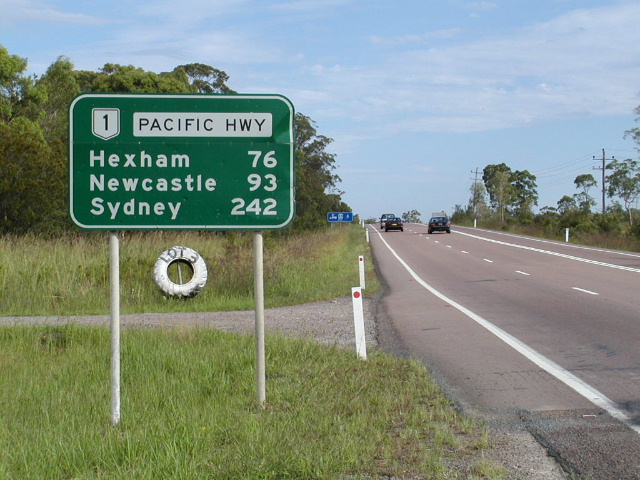
Was first signed in 1955 between Brisbane and Adelaide and subsequently extended further as more sections of highway were sealed. To this day the entire route is not sealed but in the late 1990's NT erected NH1 signs along the Wollogorang Rd to the QLD Border, leaving the only never signed section between Donors Hills (south of Normanton) and the NT Border. Through part of Queensland and all of Victoria and South Australia the route has been replaced by alpha-numeric route marking. Highway 1 also has a spur from Burnie to Hobart in Tasmania. |
||
(Townsville, QLD) |
I am unsure of the details of this route. It appears that both the old Bruce Highway route (Charters Towers Road/Ingham Road) and the original relief route (University Drive/Duckworth Street etc) were signed at various points in town. |
|
(Mackay, QLD) |
This one was found by Michael Greenslade, following the original alignment of Bruce Hwy through Mackay. Probably introduced when the Ron Camm Bridge was opened in the early 1980s and now appears to have been decommissioned as new signs are erected without reference to this route. |
|
(Brisbane, QLD) |
This route was signed in 1986 and took largely the path of the former NR1 through Brisbane. It was replaced in 1994/95 in the most part by Metroad 3. |
|
(Gold Coast, QLD) |
This route was signed along the Gold Coast Highway once the route for the Pacific Highway was completed as far as Reedy Creek in the late 1970's. It was replaced by State Route 2 in 1997/98. |
|
The current alignment of State Route 83 through Hornsby town centre. Disappeared in 1989 when National Route 1 was re-routed. |
||
This route was signed 1975-90 along the Princes Highway, paralleling the Southern Freeway. It was replaced by State Route 60. |
||
(Melbourne, VIC) |
This route was first signed in 1978 in western Melbourne and extended to the east side in 1988, when NR1 was moved onto the paralleling freeway. Today the route only exists on the east side of Melbourne and extends all the way to Beaconsfield. |
|
(Heywood, VIC) |
This route was signed haphazardly from the late-80s or early 1990s until the introduction of alpha-numeric route marking in 1997. |
|
This route was signed in the 1970's and was recently replaced by the B101 designation. |
||
This route was signed in 1979 when the bypass of Murray Bridge was opened and has recently been decomissioned (partly replaced by B55). |
||
Made up of the Lincoln and Flinders Highways, this route was signed in 1978. It has been recently replaced by the B100 designation. |
||
Fully signed in 1955, converted to a National Highway Route in 1979 and eventually replaced by alpha-numeric route marking in 1998/99. A short section in inner-western Melbourne remained until completion of the Deer Park Bypass project in 2009. |
||
(Horsham, VIC) |
It is unclear when exactly this route was signed, possibly in 1977, but was decomissioned anyway in 1997/98. |
|
This route was never fully signed, the original plan having NR12 reach NR20 near Balranald but this never eventuated, even after the route was sealed. It was replaced by alpha-numeric route numbering in 2000. |
||
This route was never fully signposted; the NSW section is still largely unsealed. In QLD, the southern 30km or so was replaced with an extension of NSW State Route 91, only to be reinstated as NR13 in 2007. |
||
Fully signed in 1955 and converted to a National Highway Route in 1979. |
||
(Ipswich, QLD) |
Commissioned following opening of the Ipswich Bypass in the late 1980s. |
|
(Stanthorpe, QLD) |
Commissioned upon opening of the Stanthorpe Bypass in the 1980s. Signage is rather poor, leaving me to question whether it has been decommissioned. |
|
Only fully signed in the late 1980's and replaced in 1995/96 with the B400 designation. A 2km section still exists in NSW. |
||
Fully signed in 1973. |
||
One of the first routes signed, it was fully signed in 1974. Converted to a National Highway Route in 1992. |
||
(Berri, SA) |
Signed along the Old Sturt Highway in 1995 when the highway was re-routed through Monash. |
|
The section between Goulburn and Canberra was signed in 1956 with other sections following as they were fully sealed. The route was never fully signed because by the time the route was fully sealed in NSW the victorian section had been replaced by the B23 designation. Converted to a National Highway Route between Goulburn and Canberra in 1979. |
||
Signed in 1991 as a bypass route through the Canberra metropolitan area. |
||
Signed in 1958, using the Mid Western Hwy through central NSW. |
||
Fully signed in 1956, converted to a National Highway Route in 1979. |
||
Fully signed in 1954, converted to a National Highway Route in 1979. The Victorian leg of this route was largely replaced by the M31 designation in 1996/97. A short inner-city section remained for some years but was replaced by State Route 55 in 2005. |
||
(Campbelltown, NSW) |
Existed for approximately 7 years along the then South-Western Freeway between Prestons and Campbelltown. |
|
Fully signed in 1960 although the route wasnt fully sealed until 1971. |
||
Fully signed in 1976. |
||
Fully signed to its original extent (Willow Tree-Narrabri) in 1974. Extended west to Bourke in 1999. |
||
Signed in 1965 between South Grafton and Collarenebri. Extended west to near Walgett in 1993. |
||
Fully signed (Seymour to Gladstone) in the late 1980's and in 1997 was re-routed to meet the Capricorn Highway at Westwood. Section between Seymour and Goondiwindi was converted to a National Highway Route in 1992. North of Goondiwindi, the Leichhardt Highway section was converted to A5 and NH39 was re-routed along the Gore Highway towards Millmerran. |
||
(Shepparton, VIC) |
Signed between 1994-97. Now is C391. |
|
(Goondiwindi, QLD) |
Very poorly signed, initiated in 1992 but most signs in town date from before then. Removed during comprehensive sign replacement program in 2006. |
|
The Olympic Highway in NSW; another route that did not appear on the original plan. Signed in 1974. |
||
This route was intially signed between Goondiwindi and Warwick in 1960 and was extended north to Toowoomba in 1970. |
||
This route appeared on a Department of Main Roads map in July 1982, shown as following the Balranald-Swan Hill road in southwestern New South Wales. Signage on the ground dating from that era indicates the route route was not signed. |
||
Allocated to the Bruxner Highway between Ballina and Goondiwindi. The Ballina-Tenterfield section was signed in 1974. The Tenterfield-Goondiwindi section will never be signed due to the decommissioning of this portion of Bruxner Highway and the impending introduction of alpha-numeric route marking in NSW. |
||
This route did not appear in the original plan and was signed in 1997 after QLD agreed to shift their alignment of NR55 near the NSW Border. The route is still not signed properly. |
||
This route extended between Port Augusta and Hawker. Converted to B83 in 1998/99. |
||
This route did not appear in the original plan and was signed in 1974. |
||
This route did not appear in the original plan and was signed in 1974. |
||
This route was fully signed in 1974 and converted to a National Highway Route in 1979. In 2002 it was replaced by the A2 designation. |
||
This route was only fully signed in 1997 when a disagreement between QLD and NSW over the route alignment was resolved. It was replaced by the A7 designation in QLD in 2007 but still remains in NSW. |
||
This route was fully signed in 1973, forming part of the main route from Sydney to Perth. In 1998/99 it was replaced by the B56 designation. |
||
Riverina Hwy - Bethanga Bridge to Deniliquin. Rather haphazardly signed east of Albury. |
||
This route wasn't fully signed until the mid 1990's when the last remaining section was sealed. In 1998/99 the route was replaced by the B64 designation. |
||
This route was fully signed in 1979, the western half of which was signed as a National Highway Route. |
||
This route was fully signed in the mid-1980's, the Mitchell Highway being largely unsealed between Cunnamulla and Charleville for many years. A section of this route was converted to a National Highway Route in 1979. Presently exists only in NSW following decommissioning of all portions in QLD in 2002 and 2007. |
||
This route has never been fully signed, with the NSW section still largely unsealed. The Victorian leg of the route was replaced by the B75 designation in 1998/99. |
||
This route was fully signed in 1976 but in 2004 was replaced by the alpha-numeric route A6. |
||
This route has never been fully signed, traversing isolated country in western NSW and southwestern QLD. |
||
(Essendon, VIC) |
This route was signed, somewhat haphazardly, from 1972 through to probably 1989. |
|
(Bendigo, VIC) |
This route was signed in 1986 as a bypass route around Bendigo. It was replaced in 1998/99 with the A790 designation. |
|
Buchanan Highway, NT. Unsealed but signed nonetheless. |
||
This route was never fully signed with a large section of the route still unsealed. The SA section has been replaced with a variety of new designations. |
||
This route was plucked from the QLD State Route system in Oct 1993 to become part of the Melbourne-Brisbane Link of the National Highway. It has since been replaced with the A39 designation and National Highway Route 39. |
||
Stuart Highway. The SA portion has been replaced with the A87 designation. |
||
Allocated to the Goldfields Highway between Kalgoorlie and Meekatharra but never signed. Appears to have been replaced by an unsigned State Route. |
||
This was one of WA's firts routes signed in the mid 1960's. In 1986 it was converted to a National Highway Route. |
||
(Kalgoorlie, WA) |
This route was signed in 1986 to provide access between NH94 and the towns of Kalgoorlie-Boulder and Kambala. |
|
This route is now all National Highway and until 1986 extended south from Perth to Albany. |
||
The Buntine Highway in NT. Not signed in NT (but classified) and not even addressed in its little foray into WA. |
||
Appeared on some 1980s maps as the Brookton Highway from Kelmscott to Brookton. I am unsure if this route was ever signed before it was replaced by WA SR40 in 1986. |
Last updated 5 April 2011 © Ozroads 2004-2011. |